
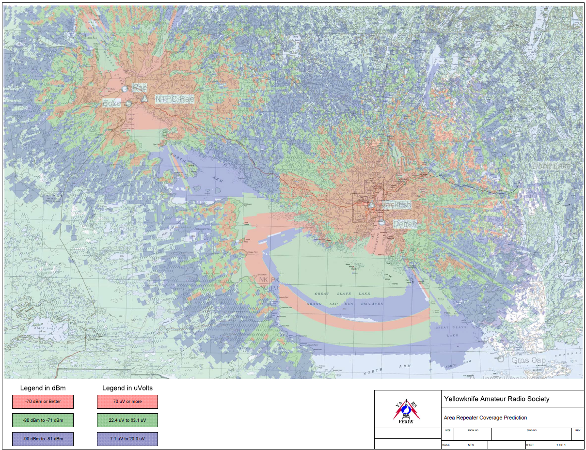
Area Repeater Coverage Map for the VE8YK and VE8RAE Repeater Network (2009)

The Yellowknife Amateur Radio Society maintains two repeaters on 2 metres that are linked.  They are the Yellowknife repeater VE8YK located on a tower at Jack Fish Lake.  The other is located on another tower located in Rae, about 1 hour away from Yellowknife (103 km), adjacent to Behchokǫ̀.  The repeater is an Internet Relay Linking Project (IRLP) node. 

Details for VE8YK:

  • Downlink / Output: 146.940 MHz
  • Uplink / Input: 146.340 MHz (Offset: -0.600)
  • Uplink Tone (CTCSS): 100.0 Hz
  • IRLP Node:  1642

Details for VE8RAE (No IRLP node but it is linked to VE8YK):

  • Frequency: 145.1500 MHz (with a -0.600 MHz offset)
  • Uplink Tone: 100.0 Hz

It should be noted that the Society is grateful to the entities who have allowed us to make use of space on their towers.  The Society maintains these repeaters on its own and through the generosity of members and others who donate time and money to the Society.  These repeaters perform a public service and have been relied upon during community events and emergencies.  For many amateurs who do not have space to put up large HF antennas, this is a quick and easy way to communicate.  The repeaters are also amenable to mobile stations.  Please consider donating to the Society.

Area coverage extends from about 45 km west of Rae to Tibbet Lake (71 km from Yellowknife).  This is probably the range in a 360 degree radius around the antennas.  Topography will have an effect.  We have reached the repeater from the Inner Whalebacks Island group in Great Slave Lake (70 km south of Yellowknife).

Basic time-of-flight principles applied to laser range-finding (Wikipedia)

The map above is called a Radio Map Estimation. As is usual, these minor observations (i.e. reflections) are the foundations of much more complex activities than simply amateur radio.  One is into the realm of Terrestrial Radar Interfrometry (TRI).  This is of course the princple behind Laser Imaging, Detection and Ranging (LIDAR).  While LIDAR uses light, we know that radio waves are a type of light - so the connection is logical.  From Google AI:  

Land-based radio reflections (or terrestrial radar) mapping is a powerful method used to understand topography, especially in environments where satellite or aerial coverage is limited, obstructed, or requires extremely high temporal resolution.
 
This technique relies on sending out radio frequency (RF) signals from a ground-based transmitter and analyzing the properties of the waves that bounce back from the landscape.
 
Here is how land-based radio reflections are used to map and understand topography:
1. Core Technologies
Terrestrial Radar Interferometry (TRI): Uses two or more antennas spaced slightly apart (or one moving antenna) to measure the phase difference of reflected radio waves. This allows for the creation of highly accurate Digital Elevation Models (DEMs).
 
Ground-Based Synthetic Aperture Radar (GB-SAR): A radar unit moves along a fixed ground rail to simulate a much larger antenna. It sends continuous radio reflections to map surface topography and track sub-millimeter changes over time.
 
FMCW Radar (Frequency-Modulated Continuous Wave): Changes the frequency of the transmitted signal continuously. By comparing the frequency of the reflection to the transmitted signal, it calculates exact distances to topographical features.
 
2. Key Applications
Monitoring Slope Stability and Landslides: Terrestrial radar is placed across valleys to monitor cliff faces or unstable hillsides. Because it uses radio reflections, it can map topography through heavy fog, rain, or night conditions, detecting structural shifts before a landslide occurs.
 
Glaciology and Ice Sheet Mapping: Ground-based radio reflections (especially Ground Penetrating Radar / GPR for subsurface topography) map the bedrock beneath glaciers, measure ice thickness, and track glacier movement.
 
Mining and Quarry Topography: Open-pit mines use land-based radar systems to continuously scan the topography of highwalls to ensure safety and map out excavation progress.
 
Volcanic Monitoring: Radio reflections can map the changing topography of a volcano's crater or dome, even when obscured by thick volcanic ash and steam.
 
3. Advantages over Aerial/Satellite Mapping
Feature Land-Based Radio Reflections Satellite / Aerial Radar (InSAR/LiDAR)
Temporal Resolution Real-time to minutes (Continuous scanning) Days to weeks (Dependent on orbit/flight schedules)
Atmospheric Interference Immune to fog, rain, dust, and clouds Can be degraded by heavy weather (LiDAR especially)
Viewing Angle Horizontal / Oblique (Excellent for vertical cliffs) Vertical / Near-nadir (Poor at capturing steep slopes)
Cost & Logistics Local deployment; high initial equipment cost but no flight fees Expensive flight logistics or high satellite data costs
4. Limitations
Line-of-Sight Restrictions: It cannot map what it cannot "see." Topographical features hiding behind hills (radar shadows) will result in blind spots.
Limited Range: Typically effective from a few hundred meters up to roughly 10 kilometers.
Surface Roughness: If the terrain is highly vegetated, the radio waves may scatter randomly or bounce off the tree canopy rather than the actual ground topography, requiring specialized lower frequencies to penetrate foliage.
 
 
To help narrow down the specifics, tell me:
Are you looking into a specific technology like GB-SAR or Ground Penetrating Radar (GPR)?
What type of environment are you trying to map (e.g., mountains, glaciers, archaeological sites)?
Is your goal to map surface terrain or see subsurface layers?